LiDAR: Not just for autonomous vehicles
The first time I ever heard of LiDAR, writes Calum McClelland, Director of BD @ Leverege in Medium, was in regard to autonomous vehicles, used as a way of identifying (and therefore avoiding) objects. Curious how it worked, I began investigating LiDAR and discovered that there are many, many applications beyond just autonomous vehicles. LiDAR is extremely useful in fields like archeology, physics, and astronomy, among others.
Since I work in the Internet of Things at Leverege, LiDAR applications in IoT are particularly interesting to me, so below I’ll share some cool use cases for LiDAR in smart agriculture, smart retail, and smart cities.
But First: How Does LiDAR Work? If you’re anything like me, you love knowing how and why things work the way they do. So I’ll share a quick explanation of LiDAR before we check out some applications.
The term “LiDAR” originated in the early 1960s as a combination of the words “light” and “radar”. Some people treat LiDAR as an acronym, either for “Light Detection And Ranging” or for “Light Imaging, Detection, And Ranging”, but such acronyms were created retroactively. Just as sonar uses sound waves and radar uses radio waves to create a map of the environment, LiDAR uses light.
LiDAR works by rapidly firing lasers (up to 150,000 times per second in some systems) at a target and then measuring the time for the light to bounce off that target and travel back to the source. Since the speed of light is constant, you can figure out the distance to the object:
Distance = (Speed of Light x Time of Flight) / 2
This will give you millions of points, called a “point cloud” in aggregate, which creates a digital mapping of the environment.
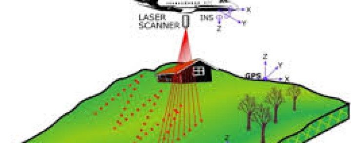
For LiDAR systems that are moving (e.g. on an airplane or on a car), you also need a position (GPS) and navigation system. Although light is literally the fastest thing there is, it isn’t instantaneous. So if you’re moving, not only do you need the time of flight for the light, but you also need the exact location of where the laser was fired and the exact location of where the returning laser is received. This lets you build an accurate point cloud like the picture above.
Applications of LiDAR: Although LiDAR has become extremely useful for autonomous cars of late, it’s had important applications for decades now. Before we jump into the IoT applications, here are two non-IoT applications that I found particularly cool. Archaeology: Planes flying with LiDAR systems can capture high-resolution models of archeological sites that can reveal micro-topography otherwise hidden by vegetation.
In 2012 LiDAR was used to find the legendary city of La Ciudad Blanca in the Honduran jungle. Despite the heavy foliage, LiDAR was able to show extensive man-made structures which ground searches had failed to find for hundreds of years. Vegetation can be filtered and “lifted” off of the underlying surface, which revealed a complex of mounds and ancient building foundations in Honduras.
Physics and Astronomy: During the Apollo program, retroreflectors were placed on the Moon. As the name implies, these retroreflectors are used to reflect back lasers that are shot from observatories on Earth. The data generated by these LiDAR systems in observatories across the world can be compared to find the exact position of the Moon measured with millimeter precision. Using these exact measurements, we’ve been able to conduct tests of general relativity.
LiDAR is also extremely useful for mapping the surfaces of celestial bodies. For lunar and martian landers, it’s critical to have accurate topographical maps so that flat landing sites can be chosen. In 2001, the Mars Global Surveyor produced a spectacularly precise global topographic survey of the red planet which has been crucial in subsequent missions to Mars.
Read more: https://iot-for-all.com/lidar-not-just-for-autonomous-vehicles-42e518a0e6eb
- ‘LIDAR: Not just for autonomous vehicles’, writes Calum McClelland (Leverege).

